4 Days
Tour Northern Colorado This Summer
Enjoy a four-day trek highlighting NoCo's remote beauty with a focus on things to do and see with lots of outdoors time. Bonus: Few reservations are needed.

Enjoy a four-day trek highlighting NoCo's remote beauty with a focus on things to do and see with lots of outdoors time. Bonus: Few reservations are needed.
This permanent funding source supports specific non-motorized trail and trailhead maintenance projects on public lands within Routt and Moffat counties. Look for “donation stations” — refurbished parking meters with credit card readers — at 11 popular local trailheads, including Spring Creek, NPR and Wild Rose. Or donate online at yvcf.org/trails.

For a true Western experience, hike Soapstone Prairie Natural Area for its wide-open vistas and nearly pristine grasslands. Hint: keep an eye out for…

Choice City Butcher & Deli in Fort Collins is a full-service butcher shop and deli that also offers breakfast, lunch and dinner. With 37 craft beers…

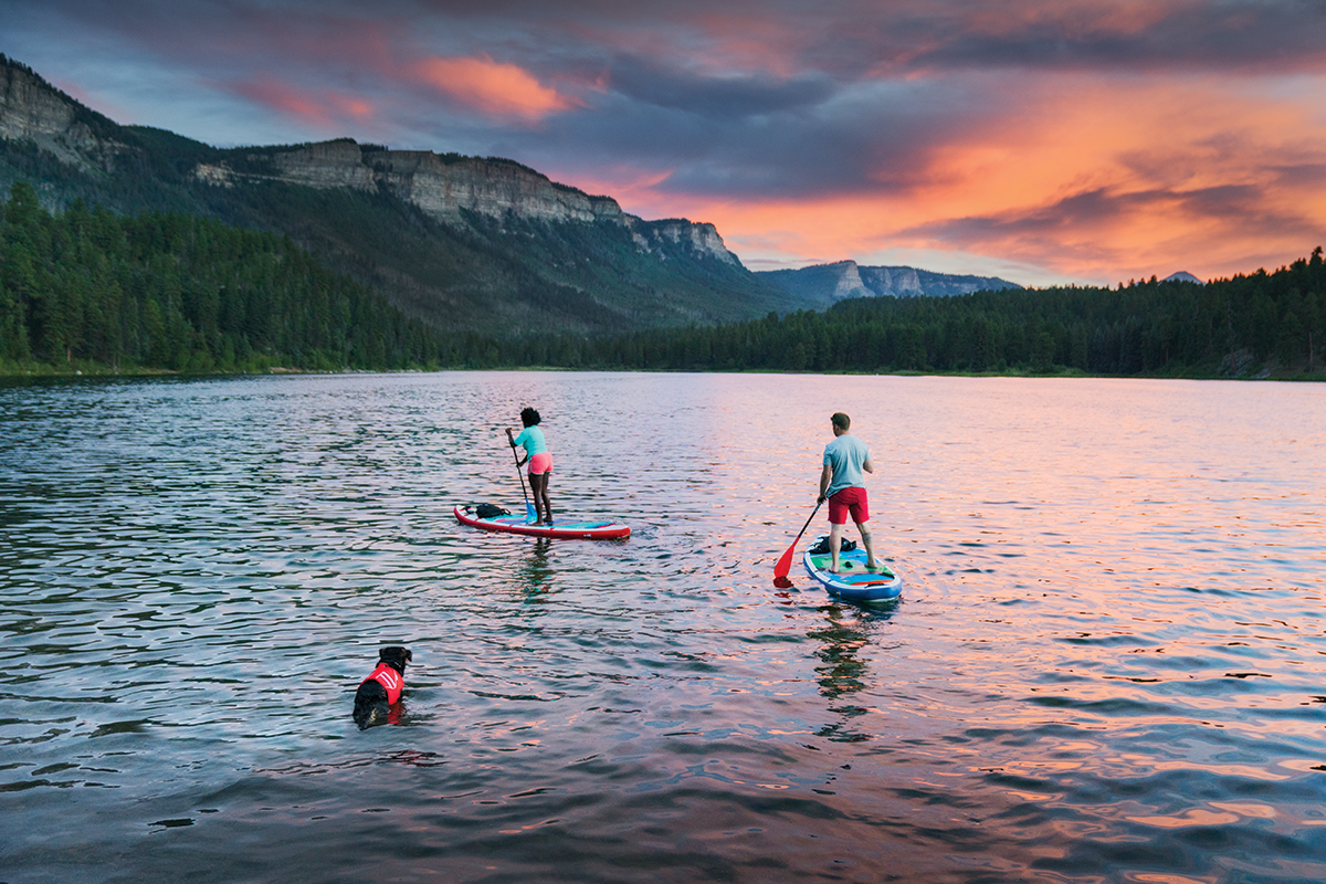
If you'd like to try one of the two wave features yourself, you can rent equipment (SUP, tubes, kayaks and gear) from a number of local outfitters.
…
Head to The Regional for home-style American food — "from the farm, from the ranch, and from the docks." Ingredients are sourced from Colorado…

Watch a movie under the Colorado night sky at one of the states last Drive-In Theaters. The Holiday Twin Drive-In is the only Drive-In Theater in northern…

The Elizabeth Hotel is where Fort Collins comes together. Situated in the center of Old Town, the cornerstone of Firehouse Alley, our Fort Collins hotel…

As a family establishment Lucile's has always strived to provide a comfortable and unique atmosphere as well as excellent food.

From Fort Collins follow Hwy. 14 and the Cache la Poudre River, the state’s only designated Wild and Scenic River, toward the spectacular Poudre Canyon…
Enjoy artisanal coffee drinks made with Morning Fresh Dairy.

The ultimate in rugged Colorado wilderness, 71,000 acres of forest, jagged peaks and alpine lakes. Features 158 campsites and 15 cabins and yurts are…
The State Forest State Park North Loop "touches on a little bit of everything that makes State Forest State Park special." That includes great views of the Medicine Bow Mountains, three pretty alpine lakes (Jewel Lake, Kelly Lake and Clear Lake), a bit of singletrack and forest road, plus towering aspen trees.

Stockman Bar is Walden's well-loved watering hole, complete with jukebox, pool tables and darts.

RAW, remote, tucked deep in Colorado's rugged Rockies, the high valley of North Park and its County of Jackson literally scream FRONTIER and a past…

Located in the heart of Walden, Antlers Inn offers rustic elegance just 2.5 miles from Walden Reservoir. It has an on-site restaurant — River Rock Cafe…
Take your time — and eat some breakfast at your hotel before heading out.

One of over 560 refuges in the National Wildlife Refuge System - a network of lands set aside and managed by the U.S. Fish and Wildlife Service specifically…


From Walden, continue west on Hwy. 14 and enjoy wide-open vistas, fields of sage and prairie grass, the occasional cattle ranch, abandoned cabins and…

A ride in the beautiful Wild West Hot Air Balloon is the experience of a lifetime, offering stunning views of the Steamboat Springs area, the Flat Top…

The Nordic Lodge offers a central location with remodeled rooms. Enjoy access to a free shuttle traveling regularly to Steamboat Ski Resort.

Freshies has been serving fresh and entirely hand-prepared breakfast and lunch for 10 years in Steamboat Springs, Colorado.

Enjoy miles of seamlessly connected multi-use trails in five main network “pockets” in and around town; all are accessible from town by foot, bike or…

Yampa Sandwich Company serves crave-able, good-for-you breakfast and lunch sandwiches and salads. The menu offers more than 20 sandwiches, a variety…

This 7.5-mile paved multi-use recreation path runs through the heart of Steamboat Springs along the Yampa River. Don’t miss these great stops (that…

Salt and Lime in Downtown Steamboat Springs is a new twist on Mexican food
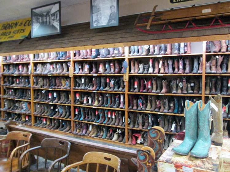
Outfittin' the West for 113 years and five generations! We are a historic western store in downtown Steamboat Springs. We were founded in 1905, and…

The Rabbit Ears Motel, located in beautiful Steamboat Springs, is your choice for comfortable, affordable lodging right in the center of downtown. Either…
Sponsored